


Medicine Lodge Precinct 4, Barber County, Kansas
About
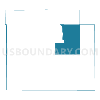
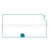
Outline

Summary
| Unique Area Identifier | 583936 |
| Name | Medicine Lodge Precinct 4 |
| County | Barber County |
| State | Kansas |
| Area (square miles) | 96.64 |
| Land Area (square miles) | 96.42 |
| Water Area (square miles) | 0.22 |
| % of Land Area | 99.78 |
| % of Water Area | 0.22 |
| Latitude of the Internal Point | 37.29800490 |
| Longtitude of the Internal Point | -98.54065340 |
Maps

Graphs
Select a template below for downloading or customizing gragh for Medicine Lodge Precinct 4, Barber County, Kansas


Neighbors
Neighoring Voting District (by Name) Neighboring Voting District on the Map
- Eagle Township Voting District, Barber County, KS
- Elm Mills Township Voting District, Barber County, KS
- Hazelton Township Voting District, Barber County, KS
- Liberty Township Voting District, Kingman County, KS
- Medicine Lodge Precinct 1, Barber County, KS
- Medicine Lodge Precinct 2, Barber County, KS
- Medicine Lodge Precinct 2 Exclave, Barber County, KS
- Medicine Lodge Precinct 3, Barber County, KS
- Medicine Lodge Precinct 5, Barber County, KS
- Mingona Township Voting District, Barber County, KS
- Nippawalla Township Voting District, Barber County, KS
- Ridge Township Voting District, Barber County, KS
- Sharon Township Voting District, Barber County, KS
- Valley Township Voting District, Barber County, KS
Top 10 Neighboring County Subdivision (by Population) Neighboring County Subdivision on the Map
- Medicine Lodge township, Barber County, KS (2,334)
- Sharon township, Barber County, KS (356)
- Hazelton township, Barber County, KS (153)
- Valley township, Barber County, KS (147)
- Elm Mills township, Barber County, KS (135)
- Liberty township, Kingman County, KS (132)
- Mingona township, Barber County, KS (78)
- Nippawalla township, Barber County, KS (35)
- Eagle township, Barber County, KS (25)
Top 10 Neighboring Place (by Population) Neighboring Place on the Map
Top 10 Neighboring Unified School District (by Population) Neighboring Unified School District on the Map
- Barber County North Unified School District 254, KS (3,307)
- Cunningham Unified School District 332, KS (1,358)
Top 10 Neighboring State Legislative District Lower Chamber (by Population) Neighboring State Legislative District Lower Chamber on the Map
Top 10 Neighboring State Legislative District Upper Chamber (by Population) Neighboring State Legislative District Upper Chamber on the Map
Top 10 Neighboring 111th Congressional District (by Population) Neighboring 111th Congressional District on the Map
Top 10 Neighboring Census Tract (by Population) Neighboring Census Tract on the Map
- Census Tract 9681, Barber County, KS (3,138)
- Census Tract 9613, Kingman County, KS (1,854)
- Census Tract 9682, Barber County, KS (1,723)